NexusBiome
Citizen-science biodiversity engagement and regional biodiversity-index intelligence.
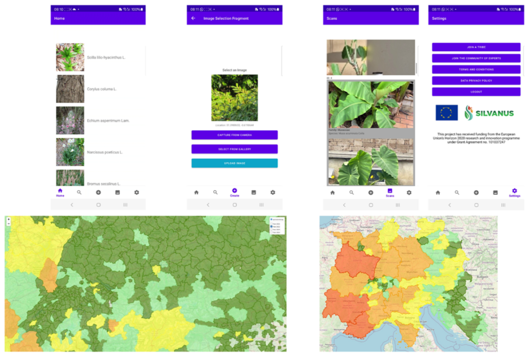
NexusBiome is a mobile-and-web platform that engages citizens with their natural environment while building structured, geolocated biodiversity intelligence at regional scale. The mobile app combines a professionally annotated tree-species reference database with prototype-learning-based image recognition, allowing users to capture, identify and contribute observations from the field.
Where NexusScout focuses on crop pests for farmers, NexusBiome focuses on biodiversity for everyone — turning everyday nature encounters into scientific data that feeds regional monitoring, landscape planning, and climate-resilience analytics through NexusAtlas and NexusFlow.
Key Features
- Mobile image capture with automatic geolocation tagging — every observation is a data point on the biodiversity map
- Prototype-learning-based species recognition — AI that improves as the reference database grows, without full model retraining
- Professional reference database with PlantCLEF lineage and continuous expansion by expert contributors
- Crowdsourced “tribe” model — community-driven data collection with expert-tier registration for validated observations
- Regional biodiversity-index visualisation — web-based dashboards mapping species richness, diversity, and ecological health
- Time-series navigation across years to track biodiversity change, seasonal patterns, and long-term trends
- Keycloak SSO authentication and GDPR-compliant data handling for secure, privacy-respecting citizen engagement
Application Areas
Citizen Science & Education
- Citizen science and public engagement with biodiversity
- Education and environmental awareness programmes
- Research data collection at scale through community participation
Monitoring & Planning
- Regional biodiversity-index monitoring for authorities and NGOs
- Landscape planning and management with a wildfire-resilience focus
- Habitat and species inventory for protected areas
Technical Specification
| Form Factor | Mobile app + web visualisation interface |
| AI Approach | Prototype learning over professionally annotated reference database |
| Data Sources | PlantCLEF-lineage reference set + geotagged crowdsourced imagery |
| Authentication | Keycloak single sign-on identity service |
| Outputs | Regional biodiversity index, time-series maps, species inventories |
| Integration | APIs to NexusFlow and NexusAtlas for landscape-resilience workflows |
| Cluster | Cluster 6 — Biodiversity & Environment |
How It Works
Capture & Identify
A citizen encounters a tree or plant they want to identify. They open the NexusBiome app, photograph it, and the system automatically captures GPS coordinates, timestamp, and device metadata. The image is processed by the prototype-learning recognition engine, which compares it against the professional reference database to return a species identification with confidence score, taxonomic classification, and ecological context. Users see not just a name but a rich species profile — habitat preferences, seasonal behaviour, conservation status, and similar species to watch for.
Prototype Learning
Unlike conventional deep-learning classifiers that require full retraining when new species are added, NexusBiome uses a prototype-learning approach. Each species is represented by a set of learned prototypes — characteristic visual patterns derived from the professional reference database. When a new species needs to be added, new prototypes are registered without disturbing the existing model. This makes the system continuously expandable: as expert contributors add validated reference images, the recognition capability grows without the computational cost and instability of full retraining.
Community & Expert Tiers
NexusBiome operates a “tribe” model with two contribution tiers. General users — citizens, students, hikers, nature enthusiasts — contribute observations that are AI-classified and geotagged. Expert-tier users — botanists, ecologists, forestry professionals — can validate observations, correct classifications, and contribute high-quality reference imagery that enriches the database. This two-tier model balances scale (thousands of citizen observations) with quality (expert validation), producing a dataset that is both broad and scientifically credible.
Regional Biodiversity Index
Individual observations aggregate into a regional biodiversity index — a composite metric that captures species richness, diversity, and ecological health at landscape scale. The web interface visualises this index as an interactive map, with colour-coded regions showing biodiversity status and trends. Users can navigate through time, comparing current biodiversity levels against previous years to identify areas of improvement, degradation, or emerging concern. Authorities use this view for planning; researchers use it for longitudinal analysis; educators use it to show students the living landscape around them.
Landscape-Resilience Integration
NexusBiome’s biodiversity intelligence feeds into NexusAtlas as a specialised data layer — enriching the geospatial digital twin with living ecological data. When NexusAtlas models wildfire risk for a forest region, the biodiversity layer adds species composition and vegetation health indicators. When NexusEarth detects land-cover change from satellite imagery, NexusBiome’s ground-truth observations validate whether that change corresponds to actual biodiversity impact. This ground-to-orbit integration is what makes the Nexus suite’s environmental monitoring genuinely multi-scale.
Why Citizen-Science Biodiversity Matters
Professional ecological surveys are rigorous but expensive and infrequent. Satellite-based monitoring captures landscape-scale change but cannot identify species on the ground. Citizen science fills the gap — providing continuous, distributed, species-level observations across areas that professional surveys visit once a year at best.
The challenge has always been data quality. NexusBiome addresses this through AI-assisted identification (reducing misclassification), expert validation tiers (catching errors), structured metadata capture (ensuring every observation is scientifically usable), and a professional reference database (providing the ground truth that the AI learns from). The result is citizen-contributed data that meets the quality bar for regional monitoring, conservation planning, and policy evidence — not just public engagement.
With the EU Biodiversity Strategy for 2030 requiring member states to designate 30% of land and sea as protected areas and to restore degraded ecosystems, the demand for scalable, cost-effective biodiversity monitoring has never been greater. NexusBiome provides the digital infrastructure to meet that demand.
Heritage & Lineage
NexusBiome was developed by VTG to integrate citizen-science biodiversity engagement with operational landscape-resilience analytics, complementing the NexusAtlas digital-twin platform. The species-recognition capability builds on VTG’s prototype-learning research and the PlantCLEF lineage of professionally annotated botanical reference data.
Target Calls: Horizon Europe Cluster 6 (Biodiversity & Environment), Mission Restore our Ocean and Waters, Mission Adaptation to Climate Change, and citizen-science and rewilding topics.
Interested in NexusBiome?
Contact us to discuss how NexusBiome can power citizen-science biodiversity monitoring for your region or programme.
Book a Call →