NexusAtlas
Multi-layered geospatial digital twin for environmental and climate-resilience operations.
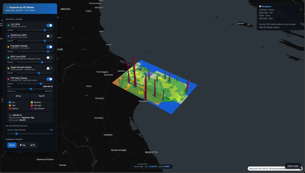
NexusAtlas is VTG’s flagship geospatial digital-twin platform, providing multi-layered GIS visualisation, interactive map-based intelligence and enhanced decision support. It integrates spatial, operational, environmental and compliance-related data into a single interactive environment — supporting interactive 3D rendering of assets, infrastructure, operational zones and site entities, each represented as a data-rich digital object linked to metadata, evidence and analytics.
NexusAtlas connects to NexusFlow for analytics-driven insights and is compatible with Earth Observation inputs from NexusEarth, creating a complete geospatial intelligence stack from satellite acquisition through to operational decision-making.
Key Features
- Multi-layered GIS with environmental, operational and compliance layers in a unified view
- Interactive 3D map-based intelligence and digital-twin objects with rich metadata
- Decision-support overlays for risk assessment and operational planning
- NexusFlow integration for analytics-driven insights and agentic reasoning over geospatial data
- NexusEarth compatibility — ingest satellite imagery and EO-derived products directly
- Shareable evidence trails and reporting outputs for audit and compliance
Application Areas
Climate & Environment
- Wildfire risk monitoring and forest management for climate-resilient forestry
- Coastal, flood and water-pollution risk visualisation
- Biodiversity and ecosystem monitoring across protected areas
Infrastructure & Operations
- Critical infrastructure resilience under climate stress
- Civil protection and emergency operational planning
- Multi-agency coordination with shared operational views
Technical Specification
| Architecture | Multi-layered GIS with 3D rendering and digital-object data model |
| Data Sources | EO feeds, IoT, ground sensors, asset databases, regulatory layers |
| Compute | GPU-accelerated geospatial and 3D processing |
| Storage | High-throughput hot storage + ≥4 TB project archive |
| Outputs | Interactive maps, evidence packs, operational dashboards |
| Integration | NexusFlow for analytics, NexusEarth for EO inputs, NexusTrust for assurance |
| Cluster | Cluster 6 — Climate, Land & Sea |
Platform Capabilities
Multi-Layered Visualisation
NexusAtlas organises geospatial intelligence into composable layers — each representing a distinct dimension of the operational picture. Environmental layers show land cover, vegetation indices, and fire weather indices. Operational layers display infrastructure assets, sensor positions, and response units. Compliance layers overlay regulatory boundaries, protected zones, and reporting areas. Users toggle, combine, and filter layers to build the view they need for their specific task.
Interactive 3D Digital Twin
Every asset, infrastructure element, and operational zone is rendered as a data-rich 3D digital object. Users navigate the environment spatially — clicking structures to inspect metadata, historical records, sensor readings, and linked analytics. The 3D model is not decorative; it is the primary interface for understanding spatial relationships, line-of-sight, terrain effects, and proximity-based risk.
Decision-Support Overlays
NexusAtlas generates risk-scored overlays by combining real-time sensor data, historical patterns, and predictive models. Wildfire risk maps combine Fire Weather Index data with vegetation dryness and terrain slope. Flood risk visualisations fuse elevation models with rainfall forecasts and drainage capacity. These overlays transform raw data into actionable intelligence that supports operational planning and resource allocation.
Evidence Trails & Reporting
Every view, overlay, and analytical output can be captured as a shareable evidence pack — preserving the data state, layer configuration, and timestamp for audit, reporting, or handover to other agencies. This is critical for civil protection operations where decisions must be documented and defensible.
Heritage & Lineage
NexusAtlas was developed and matured in the SILVANUS project (H2020, GA 101037247) for climate-resilient forest management — providing the geospatial operational platform for wildfire risk assessment, biodiversity monitoring, and multi-agency coordination across European pilot sites. The platform has been extended through TERRA for coastal and environmental monitoring and X-ALFY for advanced AI-based XR tools for Forestry 5.0.
Target Calls: Horizon Europe Cluster 6 (Food, Bioeconomy, Natural Resources, Agriculture and Environment), Mission Adaptation to Climate Change, and civil protection calls requiring geospatial digital-twin capabilities.
Explore NexusAtlas
NexusAtlas is available as a hosted platform for demonstration and evaluation. Explore multi-layered environmental data, interact with 3D digital-twin objects, and see decision-support overlays in action.
Interested in NexusAtlas?
Contact us to discuss how NexusAtlas can support your geospatial and climate-resilience operations.
Book a Call →